Starting tonight, Lowndes, Oktibbeha and Clay counties are all under a flood watch with Hurricane Isaias expected to blow through the Golden Triangle on Saturday.
By the time Isaias reaches the area, it will be too weak to be considered a hurricane, but residents should be prepared for heavy rainfall and strong winds with gusts potentially up to 45 mph, Matt Laubhan, Mississippi LIVE Weather meteorologist, told The Dispatch. Laubhan added there is also a chance of tornadoes forming in the area although they are more likely to the east of the region.

“I think people should be concerned,” Lowndes County Emergency Management Director Cindy Lawrence said. “I’m not going to say overly, but I think you should be concerned because … you don’t ever know until that eye (of the storm) actually comes on shore.”
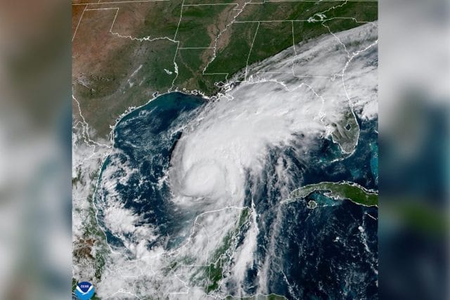
Isaias is expected to make landfall tonight along the Alabama Gulf Coast, Laubhan said. Residents of the Golden Triangle should expect some strong wind gusts and rain as early as tonight, he said.
Lawrence advises residents to remain “weather aware” this weekend and make sure to secure any outdoor property so that it does not blow away and become debris. She also said residents should charge their devices, especially any medical equipment, in case of power outages.

“I’m more worried about wind and wind gusts through our area,” Lawrence said. “I know that it doesn’t take much to down trees and power lines. They’re talking about 25 or 35 mph gusts coming, so with that you can always get power outages.”
Lowndes County is not expecting the storm to be severe enough to require storm shelters but is ready to open shelters if needed, Lawrence said.
Hurricane Isaias formed in the Gulf of Mexico on Wednesday and as of Thursday afternoon, was considered a Category 1 hurricane, with winds between 74 to 95 mph, according to the National Oceanic and Atmospheric Administration.
Isaias could reach Category 3 status, with winds above 111 mph, but it is more likely to peak at Category 2, Lauhban said. Once a storm reaches Category 3 status, it is considered a major hurricane with guaranteed devastation.
Laubhan said the storm will have weakened to less than Tropical Storm force by the time it reaches the Golden Triangle.
“Rain is probably the biggest impact, some gusty wind, but depending on the track the possibility of tornadoes I think is still on the table,” Laubhan said.
Isaias’ path still has uncertainty and could make landfall farther west.
“South Mississippi still could take the center of this storm. That is very much on the table as a possibility, despite where tracks are going a little east of that,” Laubhan said. “South Mississippi could still get very rough from this. If folks know folks down there, encourage them to obviously stay aware, and if and when necessary, get out because this one still could be very rough for folks down there.”
You can help your community
Quality, in-depth journalism is essential to a healthy community. The Dispatch brings you the most complete reporting and insightful commentary in the Golden Triangle, but we need your help to continue our efforts. In the past week, our reporters have posted 33 articles to cdispatch.com. Please consider subscribing to our website for only $2.30 per week to help support local journalism and our community.